Geological sites
There are several geologically significant sites to visit in Salla.
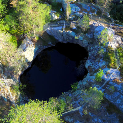
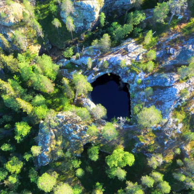
Aholanvaara is home to Finland’s largest Giant’s Kettle, which is a scenic spot to visit. The area is also strongly connected to Finland’s war history, as stones have been quarried from there for the Salpalinja stone barrier.
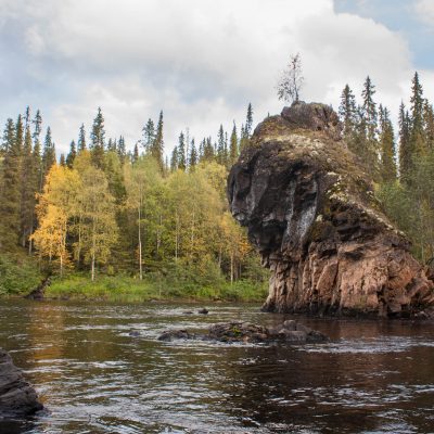
In the Oulanka National Park, in the Savinajoki located Rupakivi is a seven-foot-high stony stone statue. The Pirunkirkko Church in Tuntsa Wilderness area is a spectacular geological rubble formation along the UKK Route. The ancient shore of the Salla ice lake during the Ice Age is still visible in Matovaara, where it was located at an altitude of approximately 240 meters.
Rupakivi
Rupakivi is a majestic statue of rock, roughly 7 m high, in Savinajoki river, in Oulanka National Park. This fascinating natural formation is located along the Karhunkierros trail, approx. 4 km from the parking area at Savilampi. The site is difficult to reach due to the long walking distance and the variations in elevation on the route.
Giant’s kettles in Aholanvaara, Salla
About 10,000 years ago, the melting waters of glaciers of the last glacial period have rotated large rocks and carved into the rock rather symmetrical and smooth-edged cavities. In South Salla, on the Oulanka River, near the village of Aholanvaara, there is the Kalliovaara Hiking Trail and Finland’s largest Giant’s Kettle, Juomapata (Drinking Pot), which is located on the trail. The Kettle belongs to the group of the three largest ones in the world. With a diameter of 15.5 meters and a depth of 13 meters, the oval Kettle is a unique proof of the power of the melting waters of the Ice Age. There are three other impressive sized flies nearby, ranging in diameter from five meters to twelve meters.
Driving instructions: 42 km from Salla in the direction of Kuusamo. The distance from Hautajärvi village is 20 km from Karhujärventie past Hirvasvaara village and from there a forest car road is about 6 km to the starting point. There are signs for Hiidenkirnu along the road. Karhujärventi is about 3 km from the departure point of the Valkoinen silta (White Bridge).
The second starting point of the route is about 3 km from the White Bridge, where there are signs for the route. Hikers can be reached by hiking the 4.4 km trail. The path is marked with blue painted trees. There are two campfires along the route, one at the departure point of the White Bridge and the other about 1 km before the pots. The trail is classified as demanding, so you need plenty of time for walking. The path is surrounded by mixed forests, dry forest and rocky paths. The trail has some steep climbs and descents and bare cliffs can be slippery, especially in the rain, so good shoes are needed.
Pirunkirkko (Devil’s Church) at Tuntsa
The Devil’s Church is a spectacular geological formation, located along the UKK route at Tuntsa. This massive rock pile rises behind a swamp, along the edge of the forest.
The outcrops of the Devil’s Church are about 15 m high and are heavily fractured. It was created when molten rock was pushed up from deep in the Earth through fractures towards the surface, while pushing the surrounding rocks out of its path. The Devil’s Church rock is peridotite, containing iron and magnesium, which is strongly magnetic. This type of peridotite is more than 2500 million years old.
The Devil’s Church can be visited from either Tuntsa’s road or the Tuntsa trail. There are duckboards leading from Tuntsa’s road to the Devil’s Church, which is about 600 m.
The ancient beach of Matovaara
Ice lakes were formed at the end of the last glacial period when the edge of the continental ice was retreating. Salla’s ice lake was the largest in Eastern Lapland. It extended from Posio along Kemijoki river up to Savukoski and east to Tenniöjärvi in Russia. The ancient beach of Salla’s ice lake is still visible at Matovaara, where it was located at an altitude of approx. 237-240 m.


